As many Northerners are acutely aware, flooding can happen anywhere that water can flow.
The 10 communities most susceptible to floods are Hay River, K'atl'odeeche First Nation, Jean Marie River, Fort Simpson, Fort Good Hope, Tulita, Aklavik, Fort McPherson, Fort Liard and Nahanni Butte, according to GNWT senior hydrologist Anna Coles.
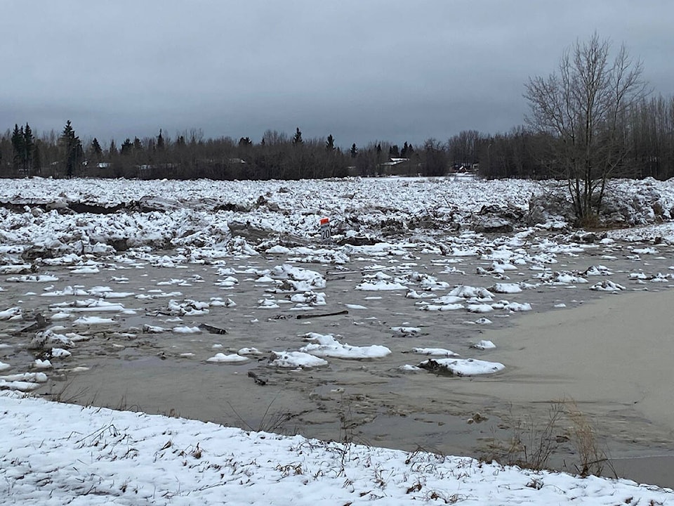
Catastrophic flooding in Hay River during the spring of 2022 forced the first of a few evacuations from that community.
"We do sometimes see flooding with prolonged rain events, especially if associated with snow melt and pre-existing high water levels," Coles said. "In general, the rivers that react the fastest to any given rainfall event are the ones that flow from the Mackenzie Mountains. A large amount of rainfall in the mountains can cause rapid rises in water levels on those rivers.
"It's hard to answer in terms of minutes, hours or more. It really depends on the landscape, on how steep the terrain is and the soil conditions and obviously the specific conditions of the rainfall event," she added.
While the main "flood season" in the NWT is focused around spring breakup and ice jams preventing melt water from flowing into the ocean, a weather warning occurred in July 2023 for Nahanni Butte due to heavy rainfall upriver. It had the potential to drop a month's worth of rainfall in 24 hours, raising the river a metre or more.
Fortunately, no damage arose from that weather event, but Coles cautioned as temperatures trend warmer and weather patterns are disrupted by climate change, the potential for extreme weather increases. In 2012, the river flooded the lower-lying parts of the community following a combination of over 70 millimetres of rain in the Mackenzie Mountains, a snowpack that was 150 per cent of its normal volume and unseasonably warm spring temperatures.
"Nahanni Butte is susceptible to rainfall-driven flooding due to its location on the South Nahanni River," Coles said. "The basin for the south Nahanni is in the Mackenzie Mountains. It's also susceptible because of its location at the confluence of the South Nahanni River and the Liard River.
"A key factor in the flood risk for Nahanni Butte is not only the high rainfall in the basin, but also if there's high existing water levels on the Liard River. That really helps us give a prior indication for when that community may be [facing] higher risk of flooding."
As climate change progresses, it's demonstrated the ability to manifest in ways not previously predicted. The 2022 Hay River flood, for example, was caused by ice jams stopping water from flowing downriver while heavy rains in Northern Alberta sent even more water into the system.
As far as being able to catch floods before they overwhelm a community, Coles said officials are able to estimate where major weather events can potentially occur and issue advisories accordingly. Employees of federal weather monitoring systems are in constant communication with GNWT officials, and notifications of potentially disruptive weather systems can come up to a week in advance.
"We're always watching hydrometric stations," said Coles. "If we know if there's a rainfall event coming, which we would get [notice of] from the federal forecasters, then that heightens our focus on that particular region. We can watch those stations in the lead up and during the event to know when and how much the river responds."
Municipal and Community Affairs senior communications and planning advisor Jay Boast said the department works to ensure communities have up-to-date emergency response plans in place.
Flood risk is also factored into community planning, he said, to ensure structures aren't built in high-risk areas or are constructed to withstand changing water levels.
Boast said many communities are equipped with emergency sirens and water levels are monitored by the Department of Environment and Climate Change regularly. In the event of an emergency, the NWTAlert system can reach phones, television and radio broadcasts to warn people.
"Whenever we have an emergency event, we do our after-action reviews to see what lessons we've learned and how they can be applied," Boast said. "In the case of a flash flood, a weather system develops quickly and dumps and amount of rain that's not expected or typical for a place. So that's why we tell people to be prepared.
"I think people are getting the sense of 'be prepared for wildfire and flood season,' but you really need to be prepared year-round, because there are a number of different things you can face."
Both Coles and Boast emphasized that anyone going out on the land should always be aware of weather forecasts and have emergency plans in place.
Carrying a grab-bag, storing important items higher up where waters might not reach them and keeping an emergency plan are steps people can take to mitigate risk.
"Being in the North comes with its own inherit risks," said Boast. "So be prepared year-round. Ask how would you take care of yourself if you were faced with an emergency situation and had 72 hours to get set up."


